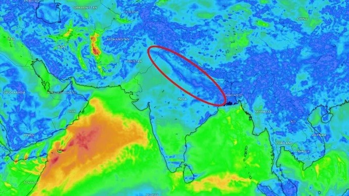
Satellite imagery has detected a crucial 1,500-kilometer-long monsoon trough extending from the northern Bay of Bengal all the way to Jammu and Kashmir. This development marks a significant turning point for the southwest monsoon, which has seen a sluggish start and left much of north India grappling with intense heat.
The India Meteorological Department (IMD) confirmed the formation of this elongated zone of low atmospheric pressure. While currently positioned close to the Himalayan foothills, meteorologists anticipate a gradual southward shift towards its normal alignment. This movement is critical, as it’s expected to trigger a substantial increase in thunderstorm activity across north India, paving the way for the monsoon to establish itself firmly in the region between July 1 and July 4.
The satellite image, captured by INSAT-3DS, vividly displays a broad expanse of dense cloud cover. This band stretches from eastern India into the Himalayan belt, providing visual evidence of a strengthening monsoon circulation after nearly three weeks of delayed progress and oppressive conditions. The trough essentially acts as the backbone of the southwest monsoon, drawing moisture-laden winds from both the Arabian Sea and the Bay of Bengal deep into the Indian mainland.
Its position is paramount to rainfall distribution. When the trough lies farther north, as it has for much of June, rainfall tends to concentrate along the Himalayan foothills. This leaves the vast northern plains, encompassing major cities like Delhi, along with states such as Haryana and Rajasthan, largely dry and exceptionally hot. This pattern has defined the weather narrative for the past month.
Delhi, for instance, continued to endure severe heatwave conditions recently, with temperatures soaring past 42°C at Safdarjung and reaching 43.4°C at Delhi Ridge. Rohtak recorded 43.5°C, while Sriganganagar in Rajasthan remained the hottest spot in the region, hitting 45.1°C. The combination of this intense heat and rising atmospheric moisture has also pushed humidity levels higher, making the conditions feel even more oppressive despite isolated pre-monsoon thunderstorms reported in parts of Haryana, Rajasthan, and the National Capital Region.
However, meteorologists are now optimistic that the evolving weather pattern strongly favors a transition to active monsoon conditions. Beyond the monsoon trough, forecast models indicate the probable development of a fresh low-pressure area over the Bay of Bengal later this week. This additional system is expected to further strengthen the monsoon flow, injecting even more moisture into northern India and setting the stage for widespread showers and thunderstorms.
These anticipated rains are projected to cover Delhi, Punjab, Haryana, western Uttar Pradesh, and Rajasthan. While isolated pre-monsoon thunderstorms might occur over the next couple of days, the likelihood of more organized and sustained rainfall will increase significantly from the middle of the week onward. If these forecasts hold true, Delhi could finally experience the long-awaited arrival of the monsoon in the first week of July, bringing substantial relief from one of the hottest and most humid spells of the season.
TL;DR
- Satellite imagery has revealed a 1,500-kilometer-long monsoon trough stretching from the northern Bay of Bengal to Jammu and Kashmir.
- This weather feature is crucial for the advance of the southwest monsoon across north India.
- The India Meteorological Department (IMD) expects the trough to shift southward, increasing thunderstorm activity.
- Widespread monsoon rainfall is anticipated to establish itself over north India between July 1 and July 4.
- The development offers significant relief after a prolonged period of intense heatwave conditions and high humidity in regions like Delhi, Haryana, and Rajasthan.
- A new low-pressure area is also expected to form over the Bay of Bengal, further strengthening monsoon flow and bringing widespread showers to the northern plains.