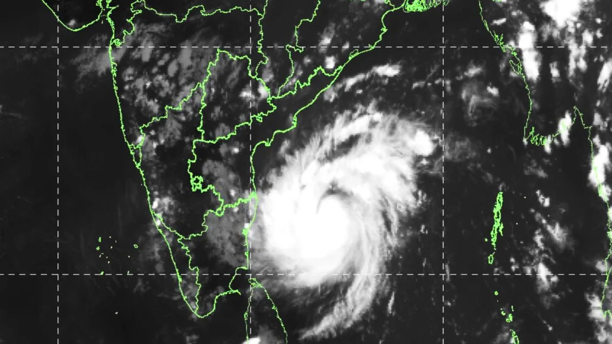

Cyclone Murasu has intensified into a severe cyclonic storm over the west-central and southwest Bay of Bengal, and it is now on a direct path toward the south Andhra Pradesh coast. Landfall is expected near Ongole, somewhere between Nellore and Narsapur, between 11:30 pm on November 2 and 4 am on November 3.
The India Meteorological Department (IMD) says the system covered about 20 km per hour in the six hours before its latest bulletin, moving northwest. At 2:30 am on November 2, the storm’s centre was located near 13.6 degrees north latitude and 82.5 degrees east longitude. That puts it roughly 260 km east-northeast of Chennai, 290 km southeast of Nellore, 320 km southeast of Machilipatnam, 310 km southeast of Kavali and 330 km southeast of Ongole. It sits about 470 km south of Visakhapatnam.
The storm is still strengthening. Forecasters expect it to grow more intense as it moves northwest, and that is the main reason coastal officials are treating this as a serious threat rather than routine monsoon rain.
Winds that can topple poles and trees
When the system reaches the coast, sustained winds of 100 to 110 km/h are likely. Gusts may occasionally climb to 120 km/h. Those speeds are strong enough to snap weak branches, tear down hoardings and bring down electricity infrastructure, and the damage has already started to show.
Power networks across Andhra Pradesh have taken heavy losses. A large number of electricity poles are damaged, and crews need personnel and machinery to restore supply. Until those lines are repaired, many homes and neighbourhoods will remain without power, especially in the hours right after the storm passes.
Six districts in the path of heavy rain
Rain is the second big threat. Heavy to very heavy rainfall is likely across several Andhra Pradesh districts on November 3 and 4. The weather impact is expected to be strongest in Eluru, Krishna, NTR, West Godavari, Guntur and Bapatla.
Within that belt, 20 mandals across the state could see extremely heavy rain. Eluru district accounts for nine of them, Krishna and NTR have five each, and Bapatla has one. Flooding in low-lying areas is the most immediate concern in these mandals, because the rain will arrive while the storm is still pushing inland.
The alert covers a long stretch of the coast and the districts directly behind it. Residents in those areas should treat the next 48 hours as the most dangerous window, not the period after the rain eases.
Andhra Pradesh asks Tamil Nadu for repair crews
The damage has pushed the state government to look beyond its own borders. Andhra Pradesh Chief Minister N. Chandrababu Naidu called Tamil Nadu Chief Minister C. Joseph Vijay and asked for staff and machinery to help restore electricity. According to the Andhra Pradesh Chief Minister’s Office, Vijay responded positively to the request.
That call shows how widespread the outage problem has become. Restoring a power grid after a cyclone takes manpower, equipment and time, and the state is clearly preparing for a long recovery effort once the storm moves inland.
What residents should do right now
Officials have told coastal residents to stay alert, especially while the storm crosses the coast. Strong winds and heavy rain are expected at the time of landfall, and the warning applies to people living in low-lying areas as well as those on the shoreline.
Stay away from electricity poles, trees and hoardings, and follow the precautions issued by officials.
Anyone in a low-lying area should be ready to move if authorities ask them to. Keep phones charged, keep emergency lights and water on hand, and avoid walking or driving through flooded roads during the storm. Do not go near fallen or hanging power lines, even if they look dead.
Cyclone Murasu is still moving, and the forecast can change as the system develops. Readers in the affected districts should keep checking official weather bulletins and local administration updates, especially as the November 2 night window approaches.
TL;DR
- Cyclone Murasu has intensified into a severe cyclonic storm and is headed for the south Andhra Pradesh coast near Ongole.
- Landfall is expected between 11:30 pm on November 2 and 4 am on November 3, between Nellore and Narsapur.
- Sustained winds of 100 to 110 km/h are likely at landfall, with occasional gusts up to 120 km/h.
- Heavy to very heavy rain is forecast on November 3 and 4 in Eluru, Krishna, NTR, West Godavari, Guntur and Bapatla districts.
- Twenty mandals may see extremely heavy rain, nine of them in Eluru district.
- Many electricity poles are damaged, and Andhra Pradesh has asked Tamil Nadu for crews and machinery.