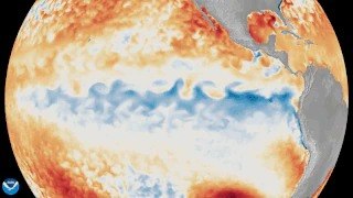
A colossal 14,500-kilometer Kelvin wave of warm water is currently traversing the Pacific Ocean, signaling the official return of El Niño, with the US weather agency NOAA predicting a 63% chance it will develop into a very strong event by winter 2026. This significant climate phenomenon, detected by NASA’s Sentinel-6 satellite, carries critical implications for global weather patterns, particularly threatening India’s vital southwest monsoon and potentially impacting agricultural output and water security in states like Telangana and Andhra Pradesh.
The detection of this massive underwater surge, which began near Indonesia and is moving east along the equator, has prompted climate scientists to issue warnings. For regions heavily reliant on monsoon rains, such as the agricultural heartlands of Telangana, a weakened monsoon could lead to significant challenges in crop yields and water reservoir levels, directly affecting livelihoods and regional economies.
What is a Kelvin Wave and How Does it Trigger El Niño?
Normally, strong trade winds blow across the Pacific from east to west, pushing warm surface water towards Indonesia and allowing cold, nutrient-rich water to rise (upwelling) off the coast of Peru. This creates a natural temperature gradient across the Pacific.
A Kelvin wave is an anomalous, slow-moving underwater surge of warm water that travels eastward along the equator. It forms when the typical trade winds weaken or briefly reverse, allowing the accumulated warm water in the western Pacific to slosh back towards the east.
As this warm water moves, it expands and causes the sea surface above it to rise by several centimeters, as observed by satellites. Crucially, it also pushes down the thermocline – the boundary between warm surface water and cold deep water – effectively shutting off the cold water upwelling near South America. This warming of the eastern Pacific is the defining characteristic of an El Niño event.
How NASA’s Sentinel-6 Satellite Detected This Phenomenon
The Sentinel-6 Michael Freilich satellite, a joint mission by NASA and its European partners launched in 2020, plays a pivotal role in monitoring global sea levels. This advanced satellite maps the height of the entire ocean every 10 days with remarkable accuracy, down to fractions of an inch.
In early March 2026, Sentinel-6 detected a far larger Kelvin wave emerging, which then rolled eastward across the Pacific. By mid-May, the satellite observed that sea levels around Peru had risen more than 15 centimeters above their long-term averages, a clear indicator of the warm water surge and the developing El Niño conditions.
Will 2026 Bring a "Super El Niño"?
The possibility of a "very strong" or "Super El Niño" in 2026 is a significant concern for climate scientists and policymakers alike. NOAA forecasters currently predict a 63% chance that Pacific sea temperatures will breach 2 degrees Celsius above average. This threshold is historically associated with the most powerful El Niño events, such as those witnessed in 1997 and 2015.
Such strong events have historically led to more pronounced global weather disruptions, including severe droughts in some regions and heavy rainfall in others. The peak impact of this El Niño is expected during the upcoming winter months.
Potential Impact on India’s Monsoon and Local Agriculture
For India, a strong El Niño is often an unwelcome guest. Historical data indicates a significant correlation between strong El Niño events and a weakening of the crucial southwest monsoon, which accounts for approximately 70% of India’s annual rainfall. A deficient monsoon can lead to widespread agricultural distress, impacting food security and the national economy.
States like Telangana and Andhra Pradesh, with their large agricultural sectors, are particularly vulnerable. Farmers in these regions rely heavily on timely and adequate monsoon rains for cultivating staple crops like paddy, maize, and cotton. A weakened monsoon could result in reduced crop yields, increased irrigation costs, and potential water scarcity for both agricultural and domestic use. While factors like the Indian Ocean Dipole can sometimes mitigate the adverse effects, the high probability of a strong El Niño necessitates proactive planning.
Preparing for Climate Shifts in Telangana and Andhra Pradesh
Given the strong likelihood of a significant El Niño event, authorities in Telangana and Andhra Pradesh may need to prepare for potential climate shifts. This could involve implementing water conservation measures, promoting drought-resistant crop varieties, and ensuring adequate support for farmers. Monitoring the progress of the Kelvin wave and subsequent El Niño development will be crucial for regional planning and disaster preparedness.
The scientific community, through agencies like NASA and NOAA, continues to track these oceanic phenomena closely, providing vital data for countries to anticipate and adapt to the evolving climate landscape. The ocean has indeed spoken, and the world, particularly monsoon-dependent nations like India, now waits and prepares.
TL;DR
- El Niño’s return confirmed by NOAA, driven by a 14,500 km Kelvin wave detected by NASA’s Sentinel-6 satellite.
- NASA’s Sentinel-6 satellite observed a 15 cm sea surface rise around Peru, indicating the warm water surge.
- NOAA predicts a 63% chance of a "very strong" El Niño by winter 2026, comparable to events in 1997 and 2015.
- This strong El Niño poses a significant threat to India’s southwest monsoon, potentially impacting agriculture and water security.
- States like Telangana and Andhra Pradesh are particularly vulnerable to a weakened monsoon, affecting crop yields and water reservoirs.
- Kelvin waves are slow-moving underwater surges of warm water that disrupt normal Pacific Ocean currents and trigger El Niño.