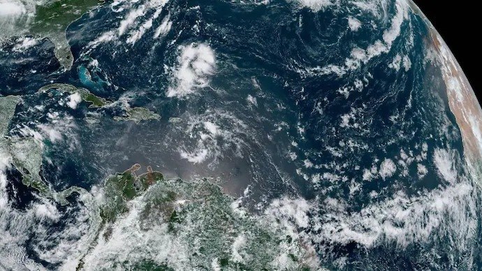
The National Oceanic and Atmospheric Administration (NOAA) has officially declared the onset of El Niño for 2026, with forecasters indicating a 63% probability that this climate phenomenon will develop into a ‘very strong’ event by winter. This declaration follows the detection of a colossal 14,500-kilometer Kelvin wave of warm water traversing the equatorial Pacific Ocean, a critical precursor tracked by NASA’s Sentinel-6 Michael Freilich satellite, raising significant concerns for India’s vital southwest monsoon and potentially impacting agricultural output and water security in states like Telangana and Andhra Pradesh.
For residents and farmers in Hyderabad and across Telangana and Andhra Pradesh, a ‘very strong’ El Niño could translate into a weakened monsoon, leading to potential drought conditions, reduced crop yields for staples like paddy, cotton, and maize, and increased pressure on already strained water resources. Understanding this impending climate shift is crucial for regional planning and agricultural preparedness.
Understanding El Niño and the Kelvin Wave Phenomenon
El Niño represents the warm phase of a natural climate cycle known as the El Niño-Southern Oscillation (ENSO). During this phase, the central and eastern equatorial Pacific Ocean experiences significant warming, which in turn reshuffles global weather patterns. Historically, fishermen in South America coined the term, meaning ‘the boy,’ due to its tendency to peak around Christmas.
The current El Niño formation is being driven by a massive Kelvin wave. Normally, strong trade winds push warm surface water towards the western Pacific, near Indonesia, while cold, nutrient-rich water (upwelling) rises off the coast of Peru. A Kelvin wave occurs when these trade winds weaken or briefly reverse, causing the accumulated warm water in the west to surge back eastward.
This slow, underwater surge, spanning thousands of kilometers, causes the sea surface above it to rise by approximately 15 centimeters because warm water expands. Crucially, it also pushes down the thermocline – the boundary between warm surface water and colder depths – effectively shutting off the cooling upwelling near South America and allowing the eastern Pacific to heat up, thus birthing El Niño.
NASA’s Sentinel-6: The Ocean’s Watchdog
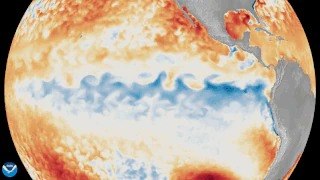
The detection of this significant Kelvin wave was made possible by the Sentinel-6 Michael Freilich satellite. Launched in 2020 as a joint mission by NASA and its European partners, this advanced satellite precisely maps the height of the entire global ocean every 10 days, with an accuracy down to fractions of an inch.
Sentinel-6 first spotted a smaller Kelvin wave near Micronesia in late January 2026, which dissipated by mid-February. However, a much larger and more persistent wave emerged in early March, steadily rolling eastward. By mid-May, the satellite data showed sea levels around Peru were more than 15 centimeters above their long-term averages, a clear indicator of the warm water surge.
Probability of a ‘Super El Niño’ in 2026
NOAA forecasters are closely monitoring the situation, predicting a 63% chance that Pacific sea temperatures will exceed 2 degrees Celsius above average. This threshold is the defining characteristic of a ‘very strong’ El Niño, often referred to as a ‘Super El Niño,’ comparable in intensity to the events of 1997 and 2015.
Such powerful El Niño events have historically led to significant global climate disruptions, including extreme heatwaves, droughts, and altered rainfall patterns across various continents. The current forecast suggests the peak intensity of this El Niño event is expected during the winter of 2026.
El Niño’s Critical Impact on India’s Monsoon
For India, a strong El Niño is often an unwelcome guest, as it has a historical correlation with a weakened southwest monsoon. The southwest monsoon is the lifeblood of Indian agriculture, contributing approximately 70% of the country’s annual rainfall and directly impacting the livelihoods of millions of farmers.
While other factors, such as the Indian Ocean Dipole (IOD), can sometimes mitigate the adverse effects of El Niño, a ‘very strong’ event significantly increases the risk of below-average rainfall. This could lead to widespread agricultural distress, particularly in rain-fed regions, and exacerbate water scarcity issues.
Concerns for Telangana and Andhra Pradesh Farmers
The potential weakening of the southwest monsoon due to a strong El Niño poses a direct threat to the agricultural sectors of Telangana and Andhra Pradesh. These states are heavily reliant on monsoon rains for irrigating major crops like paddy, cotton, and groundnut.
Reduced rainfall could lead to delayed sowing, crop failures, and a significant drop in agricultural productivity, impacting the rural economy and food security. Water reservoirs, crucial for drinking water and irrigation in cities like Hyderabad and other urban centers, could also see reduced inflows, necessitating stringent water management strategies.
Farmers in regions such as Nalgonda, Mahabubnagar, Kurnool, and Anantapur, which are already prone to drought, could face severe challenges. State governments and agricultural departments will need to implement proactive measures, including drought-resistant crop varieties, efficient irrigation techniques, and contingency plans for water distribution, to mitigate the potential impact of this impending climate event.
Preparing for Climate Shifts: The Road Ahead
The declaration of El Niño 2026 and the high probability of it becoming a ‘very strong’ event underscore the urgent need for climate preparedness. Governments, scientific bodies, and communities must collaborate to develop robust strategies for adaptation and resilience.
Continuous monitoring by satellites like Sentinel-6 and accurate forecasting by agencies like NOAA provide invaluable lead time for planning. This includes strengthening early warning systems, promoting sustainable water management practices, and supporting farmers with climate-resilient agricultural techniques to safeguard livelihoods and ensure regional stability in the face of evolving global weather patterns.
TL;DR
- NOAA has declared El Niño for 2026, with a 63% chance of it becoming a ‘very strong’ event by winter.
- A 14,500-kilometer Kelvin wave of warm water, detected by NASA’s Sentinel-6 satellite, is driving the El Niño formation.
- Strong El Niño events historically weaken India’s crucial southwest monsoon, raising concerns for agricultural output.
- Telangana and Andhra Pradesh face potential risks of drought, reduced crop yields, and water scarcity due to a weakened monsoon.
- The event’s peak intensity is forecasted for winter 2026, necessitating proactive climate preparedness and water management strategies.
- NASA’s Sentinel-6 Michael Freilich satellite provides precise ocean height data, crucial for tracking such climate phenomena.