A fresh low-pressure area has formed over the south Andaman Sea a day after Cyclone Arnab crossed the Andhra Pradesh coast, and India Meteorological Department (IMD) officials say it could affect the state. The system was spotted at around 5.30 a.m. on Thursday, October 29, 2026, under the influence of a cyclonic circulation, and it was still over the same region at 8.30 a.m.
A new system forms as the old storm fades
The timing is what makes this story urgent. Cyclone Arnab has already come ashore and lost its strength, but the storm is still reshaping the weather across four states in the east and south. The IMD’s latest bulletin shows the remnant of the storm moving inland while a second system builds over the sea.
The storm’s remnant was a depression over south Chhattisgarh and adjoining south Odisha, moving nearly northwards at 18 kmph. At 8.30 a.m. on Thursday, it was centred near latitude 19.4°N and longitude 81.9°E, about 40 km north-northwest of Jagdalpur in Chhattisgarh. The IMD expects it to weaken into a well-marked low-pressure area over north Chhattisgarh and northwest Odisha by Thursday evening.
The low-pressure area over the Andaman Sea is a different story. It persisted over the same region at 8.30 a.m. on Thursday, and the IMD says it is very likely to move west-northwestwards. It could become a well-marked low-pressure area over the south Andaman Sea and the adjoining Andaman and Nicobar Islands by Friday, October 30.
After that, the forecast gets more serious. The system is then likely to keep moving west-northwest and concentrate into a depression over the southeast Bay of Bengal and adjoining areas of the Andaman and Nicobar Islands by October 31. Forecasters have not yet said how strong that depression will become.
Why Andhra Pradesh is in the path
Officials of the IMD in Amaravati told reporters the system would “most likely” affect Andhra Pradesh. They are watching to see whether it intensifies further. That single qualifier carries a lot of weight. It means the state is not yet under a confirmed hit, but the agency is treating the threat as real enough to warn residents now.
“most likely” affect Andhra Pradesh
The IMD has already forecast heavy rain at isolated places in coastal Andhra Pradesh on November 1, 2 and 3. Those dates fall right in the middle of the state’s civic calendar. November 1 is polling day for the urban local body elections, which the State Election Commission has decided to hold as scheduled.
That means voters, election officials and polling staff in coastal districts will be heading to booths while heavy rain is forecast. The IMD’s warning covers isolated places, not the whole coast, but for anyone planning to travel or queue outdoors on polling day, the forecast is a direct safety concern.
Exceptional rain has already hit south Odisha
The remnant of Arnab did not pass quietly. In the 24 hours ending at 8.30 a.m. on Thursday, the storm dumped exceptional rain on south Odisha. The IMD recorded extremely heavy rainfall, defined as 21 cm or more, at isolated places over South Odisha and North Andhra Pradesh.
The numbers are staggering. Patrapur in Ganjam district recorded 546 mm, the highest total in the bulletin. Sorada in Ganjam received 503 mm, and G. Udaygiri in Kandhamal got 462 mm. Mahendragarh in Gajapati recorded 458 mm, Sanakhemundi in Ganjam 388 mm, and Chikiti in Ganjam 309 mm.
Patrapur is home to the Baghalati dam. That detail matters because the rain has now become a water problem downstream. Water released from the Baghalati dam has flooded Ichchapuram and nearby villages on the Andhra Pradesh side of the border. The flooding is a direct link between the Odisha rainfall and the Andhra Pradesh coast.
What it means for Andhra Pradesh
For Andhra Pradesh, the story is no longer just a forecast. The IMD reported widespread rainfall over north Andhra Pradesh in the same 24-hour window, with heavy to very heavy rain at a few places. The Ichchapuram flooding shows the threat has already crossed into the state.
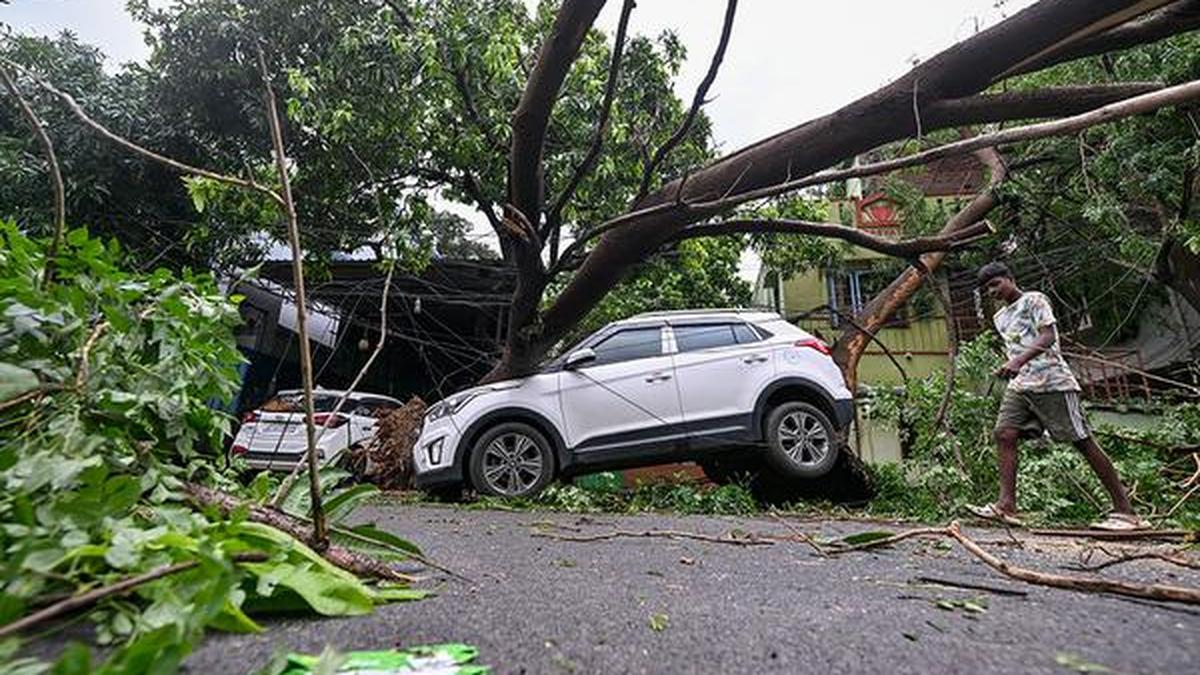
The storm’s effects were visible in Visakhapatnam too. A tree uprooted by Cyclone Arnab was photographed lying on a car in the city. That image captures what coastal residents are dealing with: fallen trees, saturated ground, and rivers and dams under pressure from rain that is still arriving.
Residents of coastal Andhra Pradesh should treat the IMD’s warnings as operational instructions. The storm has already shown it can produce extreme rainfall in a matter of hours. The new system is still being tracked, and its path could change. Until the IMD confirms its strength and track, the safest assumption is that heavy rain and flooding remain possible.
The watch continues
The IMD says the system is under continuous surveillance by Doppler Weather Radar at Raipur and Sambalpur, which are tracking the remnant over Chhattisgarh and Odisha. Officials will keep updating their assessments on whether the low-pressure area intensifies into a well-marked low or a depression.
The next few days will show whether the Andaman Sea system strengthens as forecast. The sequence is clear: a well-marked low-pressure area by Friday, October 30, a depression over the southeast Bay of Bengal by October 31, and heavy coastal rain in Andhra Pradesh from November 1 to 3. Each stage depends on the storm’s behaviour over the sea, and the IMD has said it is still watching.
For now, the message from the weather agency is plain. Cyclone Arnab has weakened, but its remnants have already caused extreme flooding in Odisha and spilled into Andhra Pradesh. A new system is forming over the Andaman Sea, and officials say it could hit the state. The coming days will test how well coastal communities and election officials can respond.
TL;DR
- Cyclone Arnab’s remnant dumped exceptional rain on south Odisha, flooding Ichchapuram and villages on the Andhra Pradesh side of the border.
- A fresh low-pressure area formed over the south Andaman Sea on Thursday, October 29, and IMD officials say it could affect Andhra Pradesh.
- The system may become a well-marked low by Friday, October 30, and a depression over the southeast Bay of Bengal by October 31.
- The IMD has forecast heavy rain at isolated places in coastal Andhra Pradesh on November 1, 2 and 3.
- November 1 is polling day for urban local body elections, which will go ahead as scheduled.
- Patrapur in Ganjam district recorded 546 mm of rain in 24 hours, the highest in the IMD bulletin.